Drone Imaging Results With OpenDroneMap
21 June 2017 12:54

I have some imaging samples from using OpenDroneMap (WebODM) to process drone imaging into georeferenced photos and textured meshes. I did a video series on this you can see here: http://www.williamwelker.com/projects.html
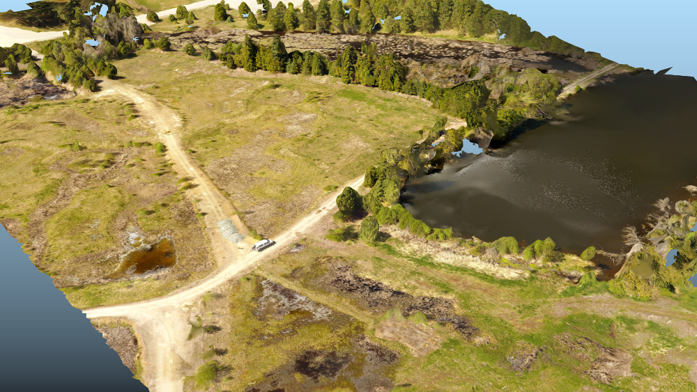
Here is a full sized JPEG. 68 MB
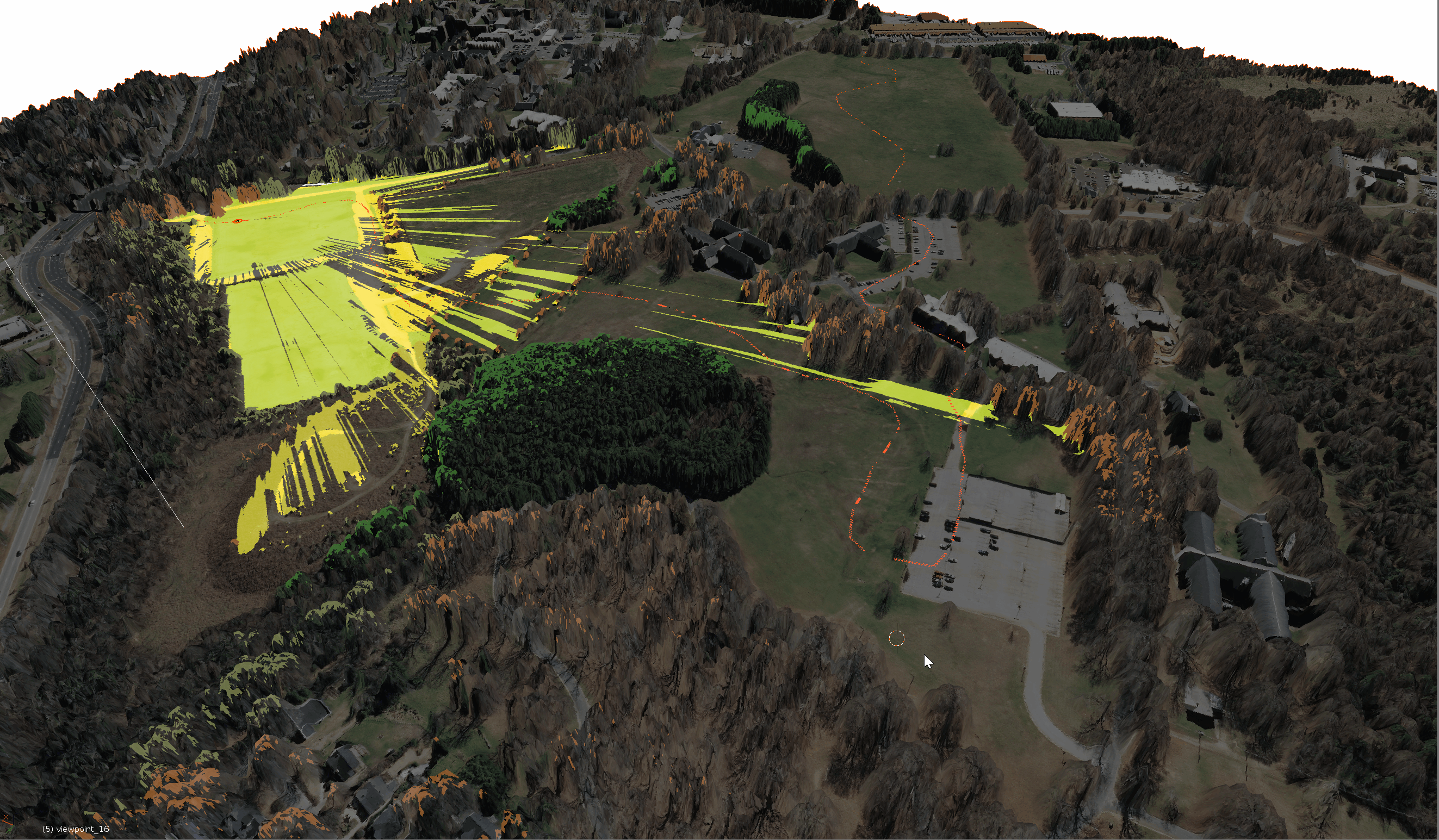
Here is a GeoTIFF image. 576 MB. This is what is actually produced by WebODM (the browser based GUI for ODM). It is a much larger file size so download this only if you want to try pulling it into QGIS or ArcGIS as a mapping layer. This is a 300 acre project. Flown with a Phantom 4 on one battery.
![]()
Making a 3D model of a project this large results in huge file sizes.
Here is a smaller section .blend file if you want to have a look. 127 MB. This renders out just fine into HTML.
The small section was flown at 250 feet with high overlap on the images to produce better 3D modeling. The larger project was more optimized for mapping so it was flown high with less overlap.
I did the large project with 22GB of ram allocated to the virtual machine.
![]()
Even with that I had to reduce the number if matching points a little in the WebODM settings.
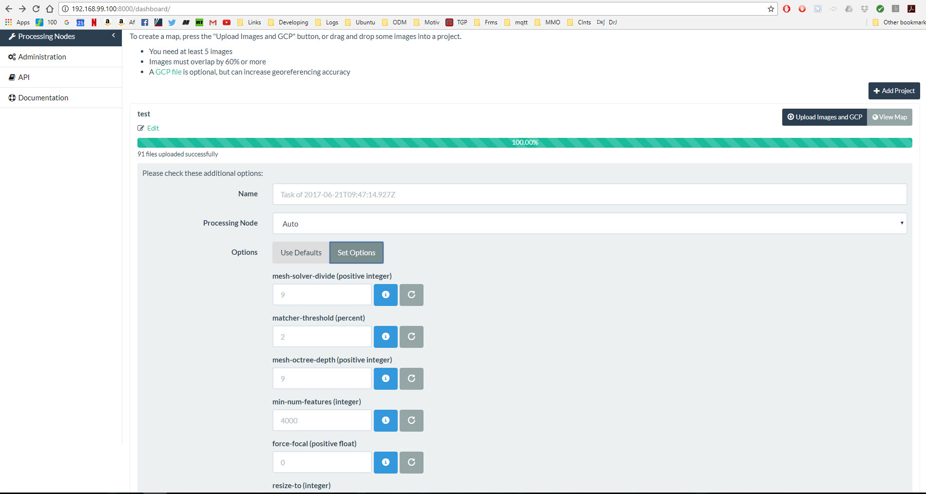
To change options, once you have uploaded your images and before you start processing, there is an options button.
![]()
Hope this is helpful. Feel free to post any questions here if you are trying to get ODM up and running. DigitalOcean has one-click Docker machine droplets(servers) if you want to try it. All you need to do is the Git clone for WebODM. ODM is under heavy development so improvements come fast.
Here is a full sized JPEG. 68 MB
Here is a GeoTIFF image. 576 MB. This is what is actually produced by WebODM (the browser based GUI for ODM). It is a much larger file size so download this only if you want to try pulling it into QGIS or ArcGIS as a mapping layer. This is a 300 acre project. Flown with a Phantom 4 on one battery.
Making a 3D model of a project this large results in huge file sizes.
Here is a smaller section .blend file if you want to have a look. 127 MB. This renders out just fine into HTML.
The small section was flown at 250 feet with high overlap on the images to produce better 3D modeling. The larger project was more optimized for mapping so it was flown high with less overlap.
I did the large project with 22GB of ram allocated to the virtual machine.
Even with that I had to reduce the number if matching points a little in the WebODM settings.
To change options, once you have uploaded your images and before you start processing, there is an options button.
Hope this is helpful. Feel free to post any questions here if you are trying to get ODM up and running. DigitalOcean has one-click Docker machine droplets(servers) if you want to try it. All you need to do is the Git clone for WebODM. ODM is under heavy development so improvements come fast.
22 June 2017 12:47
Will, thanks for sharing your experience, it is really helpful!
Here is the optimized blend file with the textures baked (15 Mb).
The exported HTML file is attached too: odm.html (19 Mb).
![]()
Here is the optimized blend file with the textures baked (15 Mb).
The exported HTML file is attached too: odm.html (19 Mb).
22 June 2017 18:10
Wow, your HTML exported file is 18 MB vs 149 MB for the original. I still have a lot to learn from the Jedi Master 
Your texture file is 4096 x 4096 and 2.6 MB so it looks like all you changed was optimizing all the texture? The quality looks the same.

Your texture file is 4096 x 4096 and 2.6 MB so it looks like all you changed was optimizing all the texture? The quality looks the same.
22 June 2017 18:36

Wow, your HTML exported file is 18 MB vs 149 MB for the original. I still have a lot to learn from the Jedi MasterWe just created a second UVMap for the mesh, then unwrapped it as texture atlas, so all pieces was placed at one UVMap without intersections and then rebaked ll materials to the new texture atlas using second UVMap.
Your texture file is 4096 x 4096 and 2.6 MB so it looks like all you changed was optimizing all the texture? The quality looks the same.
Blend4web and that kind of thing.
23 June 2017 11:52

24 June 2017 02:33
Ya, if you want to see it.
webodm_textured_mesh.blend
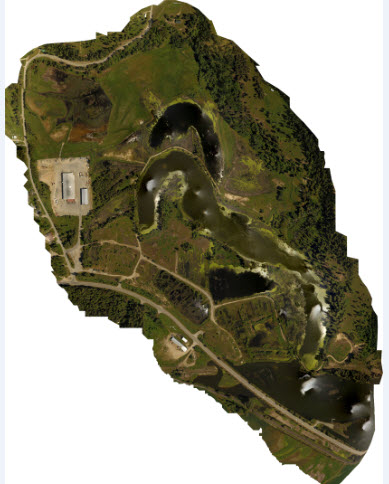
I flew this mission for a map so the 3D model is a little less detailed. If I was flying to produce a model, I would have flown lower with higher overlap.
![]()
webodm_textured_mesh.blend
I flew this mission for a map so the 3D model is a little less detailed. If I was flying to produce a model, I would have flown lower with higher overlap.

26 June 2017 12:14
Looks like Blend4Web can export it as well:
webodm_textured_mesh.html (31 Mb)
webodm_textured_mesh_optimized3.blend (21 Mb), the file is compressed using Blender's Save As dialog.
Texture is 8k now. I've also added an orange-coloured object depicting a moving vehicle at a speed of 80km/h.
BTW are the mesh dimensions real? Denoted in meters?
webodm_textured_mesh.html (31 Mb)
webodm_textured_mesh_optimized3.blend (21 Mb), the file is compressed using Blender's Save As dialog.
Texture is 8k now. I've also added an orange-coloured object depicting a moving vehicle at a speed of 80km/h.
BTW are the mesh dimensions real? Denoted in meters?
26 June 2017 22:07
That is great. This works great for reducing file sizes.
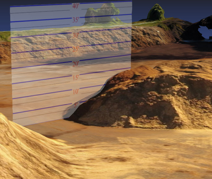
When you import the OBJ file into Blender, it doesn't keep any scale. So when I need to work at scale, I use ground control points (GCP). I measure some things on the site that will be easy to identify in Blender. You can either place aerial targets or use existing features for this. Then you can use this real world measurement to scale the model in Blender. Once scaled properly, you can make measuring devices to move around and measure things.
![]()
When you import the OBJ file into Blender, it doesn't keep any scale. So when I need to work at scale, I use ground control points (GCP). I measure some things on the site that will be easy to identify in Blender. You can either place aerial targets or use existing features for this. Then you can use this real world measurement to scale the model in Blender. Once scaled properly, you can make measuring devices to move around and measure things.
27 June 2017 15:49
15 August 2017 11:51
Here is a related project: Real-time 3D visualization of geospatial data with Blender.
This highly valued material even includes a short Blender manual!
![]()
This highly valued material even includes a short Blender manual!